Cerro Quemado: Rock Climbing in Guatemala
Rock Type: Volcanic (if you’ve never climbed on volcanic rock before, it’s incredibly sharp)
Grades: 5.8-5.14
Type: Sport, trad, some bouldering (poor landings so make sure you have a spotter)
Elevation: 3,197 meters
Approach: 30 minutes, uphill, rocky terrain
Rock climbing is unfortunately very sparse in Central America. The surge of interest in the sport that America has seen over the last two decades simply hasn’t spread to the more developing countries yet. Still, Chris and I were determined (and maybe a little overly optimistic) and still choose to haul our harness, quickdraws, carabineers, climbing shoes, and brand new 70-meter rope named Leila all the way across Central and South America. It was a huge pain and a huge sacrifice of space, but it was one we were willing to make on the off chance that we could do even a little bit of climbing.
That’s what drew us to Quetzaltenango, more commonly known as Xela. While is was way out of our path off in the west of Guatemala and boasts no real tourist attraction, it was one of two spots to climb in all of Guatemala, the other being near Lake Amatitlan in the center of the country. Still, the volcanic rocks of Xela’s Cerro Quemado, the burned hill, were meant to be the best in the country and so off we went. It was an added bonus that there is even an indoor climbing gym in the city. It’s called Complejo Deportivo de Confede and it's located near the zoo. Keep in mind than an indoor gym in Central America is nothing like climbing gyms in America. This gym is a single wall with a small bouldering section and a taller sport and top-rope section. There are few routes on it, but going there is a great way to introduce yourself to the local climbing community and maybe make some friends to climb with at the crags. The only problem with the gym is that the hours are questionable. We read online certain hours but when we met some climbers at the crag, they told us something totally different. Either way, the climbing part of the gym is only open in the evenings, from 5-8ish, though you might want to ask around about what specific days.


Where to Stay
If interested in visiting Xela for some climbing, check out my other post on how to get there. This one is designed to help you get from Xela to the climbing itself. What we’ve found is that not only is it difficult to find climbing spots in Central America, but even more difficult to find information and betas about them, so we’re doing our part to contribute. While the locals climbers of Xela have put in a lot of work creating a website, it is still lacking a beta section. We hope this helps supplement.
The easiest place to stay to access Cerro Quemado is Xela itself. There are plenty of cheap hostels near Parque Central and it’s easy to get from there to the crags. We stayed at Hostel Dona Lety, just a few blocks away from the park.
However, if you want to stay even closer, I had heard of a place to stay in Chicuá, the village at the base of the mountain. It’s called Hospedaje Elim (5379-0523), and a room costs about Q20. It’s cheaper than anything you’ll find in Xela, but keep in mind that it’s only a dorm room and the beds are box springs without mattresses or sheets. They provide blankets and a pillow, but the shower leaves something to be desired. Like a lot of Central America, it’s cold and low on pressure. You get what you pay for, but if you don’t mind slumming it, it will save you some money and let start climbing early in the morning.
Personally, we felt it was better to stay in Xela where there are more options to eat and buy groceries.

How to Get There
From Xela, it’s actually incredibly easy to get to Cerro Quemado. Despite being Guatemala’s second largest city, it’s a fast and easy trip up into the mountains from the city’s center. In fact, it’s so close that you could walk from Xela all the way to Cerro Quemado in somewhere between one and two hours. We, however, never did this. While it is definitely possible to walk from Xela, given all our climbing gear, we opted for public transportation.
If you’re interested in meeting local climbers, Sundays are the best day to go to the crags. We met a few local climbers there on Sunday who invited us to go back and climb with them on Tuesday, which we did. We even ended up climbing with Miguel Arango, the man responsible for bolting and setting almost all the routes on Cerro Quemado, his son Victor, and a few of his climbing students. All the local climbers are incredibly friendly and welcoming of gringos. So even if you don’t plan on traveling with a full rope and sport gear, you might luck out and still be able to climb there.
Walk from Parque Central to bus stop: 5 minutes
From Parque Central, it’s a five block walk to where the chicken bus you’ll need stops. Once you know where the stop is, it’s really easy to find; just go straight from the park for three blocks, turn left and walk two more blocks to the Shell gas station. The bus stops at the corner. However, if you’re trying to find it for the first time, it can be a little tricky. Our method was to walk one block, ask for directions, walk another block, then ask again. To hopefully simplify it for you, I’ve included a map below of exactly where to find the bus.
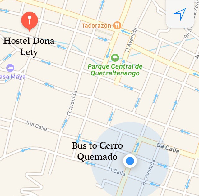
Xela toward Almolonga: Q1.50 each, 5 minutes
At the corner, a yellow school bus stops frequently and will take you up the Almolonga highway out of the city. Don’t ride the bus all the way to Almolonga, but instead tell the driver you are going to Chicuá or Cerro Quemado when you get on. After a maximum of five minutes, the bus will stop in what seems to be the middle of nowhere and they’ll direct you to get off the bus. There will be a road to the right that begins going uphill. That’s the road you need.
Almolonga highway to Chicuá: 10-30 minutes
From here, you have several options for getting from the bottom of the hill to the trailhead. If you happen to see a taxi in the area, you can take that up the mountain for a small fee. There is also an infrequent microbus that runs up the mountain that costs Q2 per person, but it runs so rarely that I wouldn’t count on this option. Out of the three days we went up to Cerro Quemado, we only managed to catch a microbus once. Your best and most reliable is option is, as usual, your own two feet. Most times, we would simply start walking up the hill, sticking our thumbs out anytime we heard a car coming up behind us. For the most part, we were very successful with this, only having to walk the full way once and hitching rides up and down every other time.
If you do walk the whole way, be aware that the road is paved, but still narrow. With cement tire tracks, there’s really only one path for cars to take, so make sure you’re not walking on it when a car approaches. From the bottom, the walk to the trailhead takes approximately 30 minutes, about 3km total. The first 2km will take you to the entrance to the Canton of Chicuá, as marked on an overhead arch. From there, you have two options for climbing: Chicuá or La Muela.
The route to La Muela is a small path that cuts up the mountain directly to the right of the Chicuá entrance arch. La Muela is primarily trad and thus we never actually visited this place, both because we don’t trad climb and because we had read somewhere online that the routes are difficult to spot.
If you’re interesting in sport climbing, Chicuá is the place to go. Continue straight for another kilometer through the village of Chicuá itself. Chicuá is a very small traditional village where it's not unusual to see people walking their cows down the main street and carrying large bundles of flowers on their heads. The villagers make their living by growing the flowers that the evangelicals scatter among the stones in the hills.
While the sharp crags of Cerro Quemado loom very obviously over the town to the right, the actual trailhead can be a little difficult to find. It’s a subtle road off to the right of the main road and upon first entering, looks more like a driveway to the house than anything. Continue past a couple vendor stalls and pig pens to the right of the house and you’ll find yourself on the mountain path. If you simply ask a local where Cerro Quemado is, they’ll point you in the right direction
Chicuá to Cerro Quemado: 30 minutes
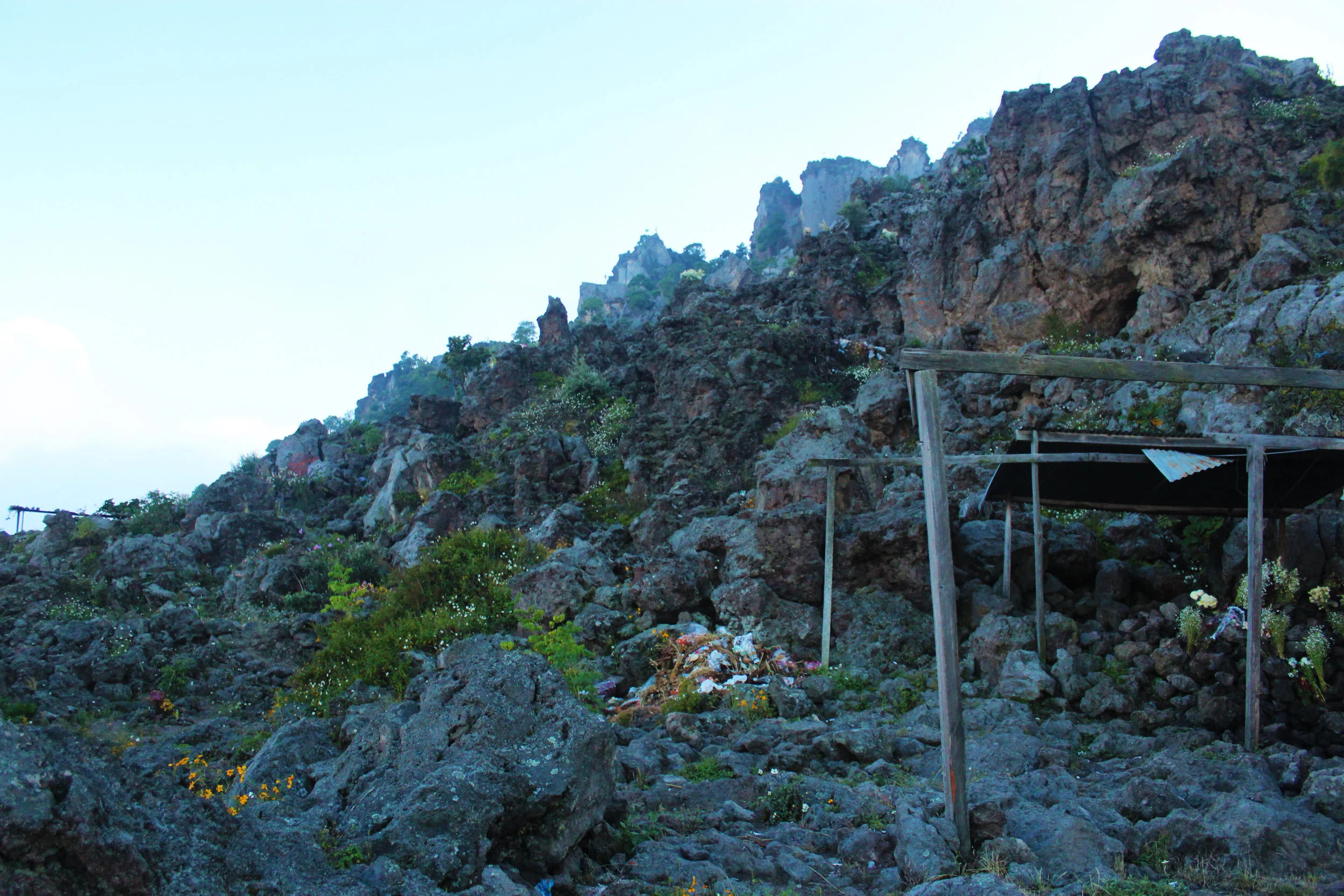
Once you begin hiking up the mountain, it won’t take long for you to realize what a strange yet wonderful place it is. The worn trail quickly disappears until it is really nothing but passable gaps between sharp, volcanic boulders. High above looms the incredibly sharp crags of Cerro Quemado. It’s a rugged, desolate landscape often shrouded in fog due to the high elevation.
If that weren’t eerie enough, your hike will likely be to the soundtrack of wailing sermons and songs. Cerro Quemado is a sacred place for Evangelicals and Mayans so don’t be surprised to stumble upon decaying bouquets of flowers and covered wooden altars hidden amid the rocks, many of them filled with devoted followers. We were there during the week of Dia de los Santos, or Day of the Saints, so it was especially busy. It can feel a little awkward passing near these religious ceremonies, but we did our best to just skirt around and respect the practices going on around us. Despite the fact that this place is so religiously significant, the worshippers are equally respectful to the climbers there and will often point you in the right direction if you look a little lost. Simply ask, “Donde esta la escala? “
The approach route itself can be a little confusing considering there is no one route. It’s generally easy enough to spot the more passable areas, but you can still find yourself on a different path from the one you intended. Out of the three times we hiked up the mountain, I don’t think we ever once used the same path. Though there are easier routes, there is no right one. Mountain Project suggests taking a guide up to the top because it is difficult to find the path, but I find that highly unnecessary. If all else fails, go up. You can see the rock formation above so just keep heading toward it. Once you reach the crags, the routes are obvious.


Area Beta
There are ten walls in Cerro Quemado, with the total number of routes landing somewhere around 33. We never found some of the walls, but the walls we never found only had a 1-2 routes on them anyway. It’s not a huge number of routes altogether, but it’s definitely enough to keep you occupied for a couple days. Most of these routes fall around the 5.10-5.12 range, though there are just a couples 5.8s, 5.9s, one 5.13, and even one 5.14 project. The 5.14 has never been sent without a hangdog.


Helpfully, the names and grades of each climb are painted on the wall at the start, so you don’t need an area guide to figure out what you’re doing up there. A word of caution: Don’t put too much stock in grading. Some are a little easier than graded and some harder. I attempted a 5.8 Called El Arete on La Vertical that I wasn’t able to complete. I know I am out of shape but a 5.8 should still be well within my capabilities. I completed another 5.8 on La Ola the next day without issue.
From left to right along the crag, the walls are ordered as follows: La Chocolatada, La Vertical, La Alemana, La Integral, El Robot, La Ola, El Culo de la Montse, and Dent-de-Lion. The image below shows the first six walls. The latter two are located further to the left of La Ola, dipping down into a small canyon.
La Chocolatada: This brown and copper streaked wall is some stunning rock, but man is it sharp. The wall is named this because when the rock is wet, it looks a little bit like melting chocolate. These routes are possible to do on top-rope, but you must climb to the top and repel down to the top chains.
· El Culto- Sport, 5.12b
· Nenas del Desierto- Sport, 5.11b
· Poc a Poc- Sport, 5.12a


La Vertical: A very smooth section of rock characterized by the narrow crack running down it, the climb for which the wall is named. Unfortunately, the crack climb is only trad.
· Arete de Catel- Sport, 5.8 (but I would contest this grade for something harder)
· Dulce Jiba- Sport, 5.11a
· La Cueva- Sport, ??? (Cueva means “cave”, and thus this climb is actually located in a cave down to the right of the wall. You must repel down to the start of this climb.)
· La Vertical- Trad, 5.11a
La Alemana: This is one of the walls that run along the very dramatic cracks splitting down the side of Cerro Quemado. As such, all the routes on this wall are trad only.
· La Alemana- Trad, 5.8
· La Tromba- Trad, ???
· Tacones- Trad, 5.8
· Tirabuzon- Trad, ???
La Integral: Again, a crack ridden area only for trad.
· La Competencia- Trad, 5.8
· La Integral- Trad, 5.9
El Robot: This wall is home to the most dramatic of the cracks, and again, it is only trad.
· Via Directa- Trad, ???
· Who’s Your Bitch? - Trad, ???
· Doble Via- Trad, 5.11a
· El Techo- Trad, 5.9
· Hambre de Rayo- Trad, ???
· Tanga Parpat- Trad, ???
La Ola: Named because the wall itself looks like a giant wave, this is the most popular wall and it had the most sport routes with a wide range of grades.
· Bolsita de Spiderman- Sport, 5.11b
· Habas de Poder- Sport, 5.11a
· Hijo de Gato- Sport, 5.13a
· La Visita del Halcon- Sport, 5.12c
· Moqueton Embrujado- Sport, 5.12a
· Sala de Maternidad- Sport, 5.8a
· Tembloron- Trad/Sport, ???
· Zapato al Ajo- Sport, 5.11a
El Culo de la Montse: This wall is located down in a little dark canyon. While there is only one route here currently, there is loads of potential for more. It’s a shame there weren’t more when we were there because the rock is incredibly interesting.
· El Canaston- Sport, 5.11a
Dent-de-Lion: If you continue through the canyon, the ground drops down once again and dead-ends. There are a couple more routes in this section.
· Indian Crack- Trad, ???
· Little Diedre- Top rope, ???
There are more routes than the ones listed above, but they’re located on unnamed walls. For instance, the 5.14 is on the wall directly behind La Ola and, to my knowledge, the wall is unnamed. There is another climb up a wide chimney near the 5.14 behind La Ola as well. There are even a few routes on some of the higher boulder crags below the main crags themselves. We stumbled upon them accidentally on the hike up. They’re over to the left closer to La Chocolatada, though I don’t know the name of the wall itself.
Hiking
Cerro Quemado is a wonderful place to visit, even if you aren’t a climber. Witnessing the fervent religiosity of the Mayan people, hearing their chants and soulful wails echoing off the rocks if haunting, albeit a little grating at times, but definitely something to experience. Even a simple hike to the top is a reward experience. At 3,197 meters, or nearly 10,000 feet, Cerro Quemado is deceptively high. While Xela itself is high enough that it doesn’t feel like you’re gaining a lot of elevation, you may find yourself getting winded quicker than usual.
The summit is most easily reached through a pass to the right of La Ola. You’ll see some rope with knots in it hanging down from an overhead chasm. By using that rope to hoist yourself up, you can reach the top in a matter of minutes. Don’t be surprised if you find yourself unable to see anything from the top, as it’s common for clouds to roll in and cloak the top of the mountain. However, if the fog clears for even a few minutes, you get a spectacular view of the valley below, from the small village of Chicua to the lower sprawling city of Xela and all the green valleys beyond. Religious aside, it’s a spiritually uplifting sight to behold.